How it works
The following applies only to the NOAA and The Russian METEOR satellites
operating in
APT (automatic picture transmission ) mode. There is also an HRPT mode
(high resolution
picure transmission) mode which is not discussed here because the cost
of the receiving
equipment plus installation and training is prohibitive to the average
person. The APT
picture data is actually derived from the HRPT picture data but is
transmiited differently.
You get the same picture at lower resolution. As on the Internet the
limiting factor is bandwidth.
Complete details of the picture transmission could fill a book. What
follows is a somewhat
simplified explantion for the APT satellites.
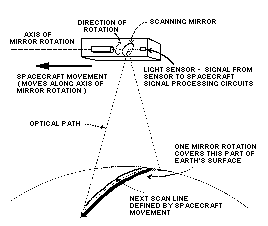
The polar orbiting environmental satellites do not take a picture of
the Earth with a camera,
rather they scan the Earth laterally with the use of a rotating mirror
directed at 1 or more light
sensors. This produces the horizontal scan line. The spacecraft movement
from pole to pole in
effect produces the vertical scan. The pixels are immediately transmiited
to Earth where they
appear line-by-line on your computer at the rate of 2 lines of 2048
pixels each per second
You actually get 2 pictures (NOAA only), one taken in visible light
and one taken in infra-red.
Depending on how you select the sofware setup you can view the pictures
side-by side on one
screen or one at a time. Since most monitors can only display 640 pixels
per line you get better
resolution selecting one picture at a time. On your end of course you
need an antenna (usually
omni-directional) a low noise preamp, a satellite receiver that tunes
the 137.5 MHz. band, a
satellite demodulator board and special software. A complete package
of this equipment can be
had for under $500.
What you see.
The satellite radio transmission is strictly line-of-sight therefore you
can only receive when they
are in range. Since the satellites are about 500 miles up, they begin
to come in range when they
are 2500 to 3000 miles away. In New York for example you can receive
images from northern
Canada to as far south as Cuba. Expect some noise on the picture at
both ends of the pass. The
picture appears as a strip approximatley 1500 miles wide which will
scroll off your screen but is
stored in memory. The usual procedure is to save only the portion of
interest, do some image
processing and save it as a GIF or TIFF file as the raw satellite file
in memory is usually 3.5 to
4 Mbytes. By using only one screen full and saving it as a GIF you
can usually cut it down to
under 200 Kbytes for 64 levels of gray. The pixels are 8 bits wide
which should give 256 levels
except that with color monitors to produce gray you have to use an
equal amount on all 3 CRT
guns. This leaves only enough bits for 64 levels. The human eye can
detect only 32 levels so it
doesn't really matter except for scientific measurements. The environmental
satellites do not
transmit in color so the usual procedure is to colorize it manually.
In HRPT mode the picture
is transmiited in 5 channels (one for each sensor) which can be translated
into color . In that
case each picture is 200 megabytes but that's another story.
To get a better understanding of the complexity of the satellite see
this detailed DRAWING.
RETURN TO FAQ
RETURN HOME
DIRECTORY
last update 3/13/99